Showing 30 items matching mt franklin
-
 Victorian Interpretive Projects Inc.
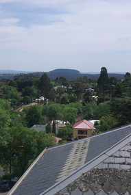
Mt Franklin from the Convent Gallery, Daylesford, 2015, Clare Gervasoni, 16/10/2015
... Mt Franklin from the Convent Gallery, Daylesford, 2015...Mt franklin..., 3350 goldfields Mt Franklin from the Convent Gallery ...The Convent Gallery was formerly Holy Cross Convent in Daylesford, which was run by the Presentation Sisters. Mount Franklin is named after John Franklin.The pine covered Mount Franklin dominates the horizon line as seen from the top floor of the Convent Gallery, Daylesfordmount franklin, mt franklin, holy cross convent, convent gallery, daylesford -
 Ballarat Heritage Services
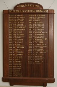
Photograph - Colour, Honor Board, Worshipful Masters Mt Franklin, St George Lodge 1943-2007
... Honor Board, Worshipful Masters Mt Franklin, St George...mt franklin and st george lodge... Masters Mt Franklin, St George Lodge 1943-2007 mt franklin and st ...mt franklin and st george lodge, daylesford, freemasons -
 Kew Historical Society Inc
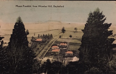
Postcard, Mount Franklin From Wombat Hill, Daylesford
... mt franklin...Coloured postcard looking north from Daylesford to Mt... postcard looking north from Daylesford to Mt Franklin. One ...One of a number of 'real photo' and commercial postcards created by or owned by members of the Christian and Washfold families of Kew. The postcards are part of a larger collection of photographs, postcards and publications donated to the collection in May 2021.Coloured postcard looking north from Daylesford to Mt Franklin.mt franklin, wombat hill, daylesford, postcards, landscape photography, christian-washfold collection -
 Victorian Interpretive Projects Inc.
Photograph - Colour, Clare Gervasoni, Mount Franklin From Franklinford Cemetery, 2015, 25/10/2015
... Mt Franklin...The Mt Franklin Aboriginal Protectorate was in the shadow... Franklin from Mount Franklin Cemetery. The Mt Franklin Aboriginal ...The Mt Franklin Aboriginal Protectorate was in the shadow of Mt Franklin. Edward Stone Parker, the Assistant Protector of Aborigines in charge of the Mt Franklin Protectorate is buried in the Mt franklin Cemetery, along with a number of the Aboriginal people from the protectorate.Two images showing the pine covered Mount Franklin from Mount Franklin Cemetery.mount franklin, mt franklin, mt franklin aboriginal protectorate, edward stone parker, e.s. parker, mount franklin protectorate -
 Ballarat Heritage Services
Photograph - Photograph - Colour, Clare Gervasoni, Former Franklinford Church, 2015, 25/10/2015
... Franlinford is associated with the Mt Franklin Aboriginal...Photograph of a brick building - the former Mt Franklin... Mt Franklin Church, and associated plaque. Franlinford ...Franlinford is associated with the Mt Franklin Aboriginal Protectorate. Photograph of a brick building - the former Mt Franklin Church, and associated plaque.franklinford, religion, church, e.s. parker -
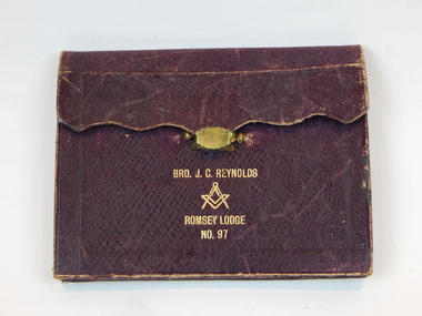 Freemasons Victoria - Mt. Franklin St. George No 12
Regalia wallet, Late 19th Cenutry
... Masonic J.C.Reynolds. Masonic wallet Romsey lodge Mt... English Constitution.) Mt Franklin Lodge of Hiram amalgamated...Freemasons Victoria - Mt. Franklin St. George No 12 16 ...The wallet is inscribed Bro J.C. Reynolds who was Initiated into freemasonry on 8 July 1880, passed to the Second Degree 5 August 1880 and Raised to the Third Degree 2nd. September 1880. Annotated ' Mount Franklin Lodge of Hiram. 716. E.C.. In 1889 this Lodge became No. 12 Victorian Const.' (E.C. denotes English Constitution.) Mt Franklin Lodge of Hiram amalgamated with St George Lodge no. 119 to be Mt Franklin St George Lodge No 12.Masonic regalia was often carried in these wallets to lodge meetings. Mt Franklin Lodge of Hiram amalgamated with St George Lodge no. 119 to be Mt Franklin St George Lodge No 12. The wallet was donated by the Hon. Thomas Carter Reynolds who is a now a retired member of the Victorian Parliament.Brown regalia wallet Bro J.C. Reynolds/ Square and compass/ Romsey Lodge No 97 all in gold. masonic j.c.reynolds. masonic wallet romsey lodge mt franklin st george lodge no 12 romsey lodge -
 The Beechworth Burke Museum
Geological specimen - Basalt (igneous-volcanic) containing Olivine, unknown
... Mt Franklin, Victoria, Australia... specific nature of Mt Franklin as a significant volcanic site ...This particular geological specimen was found in Mount Franklin or Lalgambook in Djadjawurrung, located between Daylesford and Newstead, approximately ninety minutes drive from Melbourne. The mountain is an example of a breached scoria cone (a steep conical hill of loose pyroclastic fragments) which was created by a volcanic eruption about 470,000 years ago, a date which may indicate the age of this geological specimen. The volcanic eruptions of Mount Franklin were most likely witnessed by members of the Dja Dja Wurrung Aboriginal tribe, who referred to this country as the 'smoking grounds'. Mount Franklin and the surrounding area appears to have been a place of considerable religious significance to Aboriginal people, there is evidence which indicates that frequent large ceremonial gatherings took place in the area. Basalt is the most common rock on Earth’s surface, more than 90% of all volcanic rock on Earth is basalt. Basalt is an aphanitic extrusive igneous rock formed from the rapid cooling of low-viscosity lava exposed at or very near the surface of a rocky planet or moon. Specimens are black in colour and weather to dark green or brown. Basalt is rich in iron and magnesium and is mainly composed of olivine, pyroxene, and plagioclase. Olivine is the name of a group of rock-forming silicate minerals with compositions ranging between Mg2SiO4 and Fe2SiO4. Unlike other minerals, Olivine has a very high crystallisation temperature which makes it the first of the minerals to crystallise from magma. As magma cools, the crystals begin to form and settle on the bottom of the lava and form basalts that are abnormally enriched in olivine in the lower part of lava flows. According to H. M. King (on geology.com) "Olivine is thought to be an important mineral in Earth's mantle. Its presence as a mantle mineral has been inferred by a change in the behaviour of seismic waves as they cross the boundary between Earth's crust and mantle". Lava from Mount Franklin and other volcanoes in the area filled valleys and buried the gold bearing streams that became the renowned ‘deep leads’ of the gold mining era. In 1852, as part of the Victorian gold rush, gold was discovered in the immediate area, this gold was created by lava flows during the Newer Volcanic period, which were mined intensively during the nineteenth century. Around 1865 the presence of a deep lead in Mount Franklin was established. Deep lead mining was initially unsuccessful, and it was not until the late 1870s that the Franklinford Gold Mining Company mined at Mount Franklin on a significant scale. A few years later the Mount Franklin Estate Gold Mining Company also struck gold, followed by the Shakespeare and Great Western companies in the mid-1880s. By the late 1880s, however, deep lead mining had ceased in the area. Soon after gold was discovered in 1851, Victoria’s Governor La Trobe wrote to the Colonial Office in London, urging ‘the propriety of selecting and appointing as Mineral Surveyor for this Colony a gentleman possessed of the requisite qualifications and acquaintance with geological science and phenomena’. Alfred Selwyn was appointed geological surveyor in Australia in 1852 which began the Geological Survey of Victoria. In 1853-69 the Geological Survey issued under Selwyn's direction sixty-one geological maps and numerous reports; they were of such high standard that a writer in the Quarterly Journal of the Geological Society of London bracketed the survey with that of the United States of America as the best in the world. During his years spent in Australia, Selwyn collected numerous significant geological specimens, examples of which are held in collections such as the Burke Museum.This geological specimen is an example of basalt and olivine which shows the volcanic lava activity and geographical specific nature of Mt Franklin as a significant volcanic site. According to Agriculture Victoria 'The crater is one of the deepest in the Central Highlands area. It is a major megacryst site with some of the largest known Victorian examples of megacrysts of augite and an orthoclase. The small parasitic mound of Lady Franklin on the western flanks adds to the geological interest of the site'. This specimen also highlights the locality as a significant place for both indigenous activity and Victorian gold rush era mining practices. This specimen is part of a larger collection of geological and mineral specimens collected from around Australia (and some parts of the world) and donated to the Burke Museum between 1868-1880. A large percentage of these specimens were collected in Victoria as part of the Geological Survey of Victoria that begun in 1852 (in response to the Gold Rush) to study and map the geology of Victoria. Collecting geological specimens was an important part of mapping and understanding the scientific makeup of the earth. Many of these specimens were sent to research and collecting organisations across Australia, including the Burke Museum, to educate and encourage further study.An angular, solid hand-sized piece of grey volcanic Basalt with green/brown Olivine phenocrysts along one flat edge.Olivine in basalt / - label is probably / correct. / C. Willman / 15/4/21burke museum, beechworth, indigo shire, beechworth museum, geological, geological specimen, mineralogy, basalt, igneous rock, igneous-volcanic, volcanic geology, volcanic, olivine, olivine specimen, basaltoid -
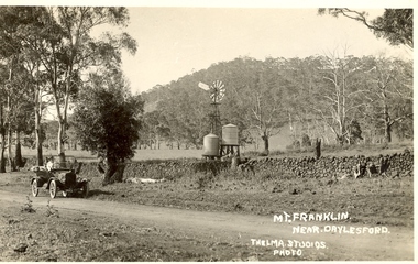 Ballarat Heritage Services
Photograph - Postcard, Thelma Studios, Mount Franklin Near Daylesford
... wall, with Mt Franklin in the background. ...Postcard Photograph Mount Franklin Near Daylesford Black ...Black and white postcard of a car in front of a drystone wall, with Mt Franklin in the background. mount franklin, volcano, drystone walls, lalgambook -
 Federation University Historical Collection
Document, Zelda Martin, Central Victorian Goldmining towns - Boom Towns or Ghost Towns?, c1996
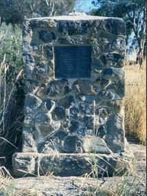
... Mt Franklin Memorial Cairn... relics ( Castlemaine Fryerstown Vaughan Mt Franklin Hepburn... relics ( Castlemaine Fryerstown Vaughan Mt Franklin Hepburn ...Zelda Martin was a PhD candidate at the University of Melbourne.[.1] 4th item in light blue display book titled Research Approach/Overview of Chapters/Confirmation of Canditure/Chapters1,2,3&4 of proposed thesis. *Twenty-seven page article on Victorian goldfields towns titled: Central Victorian Goldmining Towns - Boom Towns or Ghost Towns. The article was written during the author's PhD study. It outlines the context methodology, and resources and the chapters of the proposed thesis: (1) Central Victorian Goldmining Towns - The Context (2) Contemporary Views of the Factors Necessary for Town Growth (3) Outward Manifestations of Town Growth (4) The Trappings of Government (5-9) The Main Towns and Their Hinterland. [.2] 5th item in Light Blue display book as above item. *Chapter 1 of proposed thesis titled 'Pick, Shovel and Tin Dish Mining.' Covers in Section A: Central Victoria - Pre 1851: Aborigines in Central Victoria, Squatters, and Government. Section B: The years 1851-1854: The Early Gold Rushes, Government Reaction, Township Surveys, Legislation, Town Development, Local Government and Early Settlement. [.3] 6th item in Light Blue display book as above item. *2A of proposed thesis titled 'Contemporary Views of the Factors Necessary for Town Growth'. Similar information to Chapter 1 plus extra re towns and maps. Sections: Introduction, Context of Place - Geographical Towns Listed, The Context of Time - Pre1851 Aborigines, Governance of Port Phillip, The Squatters, The Villages of Central Victorian Highlands, Conclusion, Condensed Version of Chapter2B. [.4] 7th item in Light Blue display book as above item. *Chapter2B of proposed thesis. Sections: Area of Research, Schools, Banks, Newspapers, Progress Association, Town Development - Sandhurst (Bendigo), Ballarat, Castlemaine,, Maryborough, Ararat and Stawell. [.5] 8th item in Light Blue display book as above item. *Chapter 3 of proposed thesis titled 'Outward Manifestations of Town Growth'. Sections: Introduction, Contemporary Writing, Educationalists, The Bankers, The Townsfolk, Current Theory, General Theories of Urban Development, and Conclusion. [.6] 9th item in Light Blue display book as above item. *Chapter 4 of proposed thesis titled 'Trappings of Government' Sections: Introduction, Early Government Attitudes to Mining and Town Development, Law and Order, Township Surveys, Legislation, Local Government, Transport and Communication, The People and Lobbyists. [.7] 10th item in Light Blue display book as above item. *'The Rise and Fall of Central Victorian Goldmining Towns'. Includes a map showing main Goldfields, a table showing towns and villages at two points in time - 1857 and 1871; a Bibliography of Primary and Secondary Sources. [.8] Resource No1. Black display book titled Local Towns 1 : Alma: *Brief history *Directory *Maps Amphitheatre / Mountain Hut: *Brief History Post Office Directory Ararat: *Brief History *Post Office Directory 1869 - Alphabetical Listing by Occupation *Ararat - Prominent Citizens of 1858 *Langi-Morgala Museum Avoca: *Brief History *Excerpts from 'Avoca The Early Years', Margery and Betty Beavis; pg1 - Beginnings; pg11 - The Midas Touch; pg25 - Local Gold Escorts; pg27 - A Town is Born; pg51- The Administration of Justice; pg53 - The Ways of the Law; pg61 - News of the Day; pg65 - A Time to Play; pg72 - Land Ownership *Post Office Directory (Bailliere's) 1869 *Tourism Map and Information of area *Historic Avoca - A 5.5km Tour *Avoca & the Pyrenees Region - information pamphlet Ballarat: *Early History of Ballarat - Ballarat Historical Society, Publication No.1: origin of the name; Ballaarat - the Beginning; Fabulous Yields from the Ballaarat Goldfield; *Streetscape Lydiard Street. *Hand drawn map showing Leigh River, Old Portland Bay Road, plaque on road to Colac; etc. *Newspaper article re 'The Theatre Royal' ( which stood in the vicinity of the current Owen Williams store) - 'The News'15/04/1998 *Article - 'Ballarat's Mechanics' Institute Lives On' Ballarat Courier, 14/09/1985 *Article - Standing the Test of Time' The News 17/11/1993 re The Mechanics Institute & picture of the Reading Room *'Ballarat a Study of a City, Phyllis Reichl, pub. Nelson, 1968; no.3 place, time and people field studies series *Investigator Vol.33 No.2, 1998 Geelong Historical Society. Article on pg75 describes Ballarat in 1861 *Folded poster - 'Ballarat 100' a history of telegraph communication, pub. Telecom. Beaufort (Fiery Creek): *Brief history *Post Office Directory [.9] Resource No.2 Black Folder Titled Towns cont.No2 Bendigo (Sandhurst): *'Family & Local History at the Bendigo Library - 1851-2001 150 years of gold'. *Bendigo Government Camp in 1853 illustration; key to sketch and names of Government officers stationed there *Excerpts from 'Bendigo and Vicinity' Adolph Haman *The Bendigo Goldfield Registry - pgs 1-7 Introduction *Excerpt: 'Breaking the Grip' *Excerpt: The Most Go-Ahead Place *Excerpts from 'History of Bendigo' - anti license agitation; laying out of town; proposed railway; gold calls and dividends; the Sandhurst Municipality; journalism *Bibliography Blackwood: *Excerpts from 'Aspects of Early Blackwood - The Goldfield, the Landmarks, the Pioneers' Alan J Buckingham and Margaret F Hitchcock, JG Publishing,1980 Buninyong: *A Brief History *Investigator Vol1 No.2 Feb 1966 Geelong Historical Society. Pg3 - Article re gold escort route - Mt Alexander to Adelaide - (see a simple monument on the Western Highway a few miles out of Horsham. Pg 15 - Ballarat Excursion - re the finding of gold. *Three articles published by Buninyong and District Historical Society Inc: (Magpie Exploration; Finding Gold In The Green Hills; Magpie Exploration; Burnt Bridge to Cargarie to Mt Mercer) *Copies of newspaper articles/items *Buninyong Street Directory Carisbrook: *In the Beginning There Was Carisbrook *The History of the Carisbrook Racecourse Carngham / Snake Valley: *Brief History *Directory Castlemaine: *Directory 1865-1866 - Alphabetical and Street *Poster - Castlemaine A Contemporary Guide "The Great Centre" 1866 - A Contemporary Guide to the Fascinating Past *Pamphlet - Castlemaine District Community Hospital *Map - Castlemaine, Maldon & Surrounding Districts *Map and Information - The Dry Diggings Track - a 55kl walk among historic goldfields relics ( Castlemaine Fryerstown Vaughan Mt Franklin Hepburn Daylesford) *Postcard - Former Court House *Directory 1867 - Alphabetical, Trade [.10] Resource No.3 Grey folder Titled Towns 3 Creswick to Maryborough Creswick: *Brief History *Booklet - "Creswick Cemetery Walk" *Booklet - The Buried Rivers of Gold Heritage Trail Creswick *Creswick Historical Museum Information Sheet *Chronological History of Creswick *Alphabetical Directory of the Borough of Creswick *Creswick's Creek Directory 1856 *Historic Creswick Walking Tour *A Brief Account of the Schools of Creswick - Past and Present *100 Years of Railway Travel in Creswick *The Berry Deep Leads *The Spence Home at Jackass Gully in the Creswick State Forest ( William Guthrie Spence - Pioneer) *The New Australian Mine and the 1882 Disaster *Creswick District News, Issue 7, July August 1999 *The Creswick Miners Walk - Information and Map *Maps Chewton: *Brief History *Directory Clunes: *Brief History *Clunes Street Directory Daylesford: *Brief History *Notable Bushfires in Daylesford District Over More Than a Century - "Black Thursday" 1851; 1862; 1899; the Disastrous Hepburn Fire of 1906; 1939; 1944; 1969. *Post Office Directory -Daylesford and Hepburn Dunolly / Inkerman: *Brief History *Directory *Pamphlet - Goldfields Historical Museum *Pamphlet - Historic Dunolly - Victoria's Best Kept Secret *Map of Gold Workings at Dunolly Area - showing where the main gold rushes occurred *Brief History - Inglewood *Directory - Inglewood - Name Occupation, Dwelling Kingower: *Brief History *Directory - Name / Ocupation / Dwelling Linton / Happy Valley / Piggoreet: *Brief History *Directory - Lintons McIvor: *"A History of the Shire and the Township of Heathcote" by J.O. Randell Majorca: *Brief History *Official Post Office Directory 1869 - Name / Occupation/ Address Maldon (Tarrangower): *Brief History Part 1 *Brief History Part 2 *Post Office Directory *List - Alphabetical Order by Names plus Business and Trade (Tarrangower Times Oct/1858) *List - Alphabetical Order by Trade plus Name and Business *Directory - Name / Occupation / Dwelling Maryborough: *Worsley Cottage - built by Arthur Worsley, a contractor in stonework in 1894 [.11] Resource No. 4 Blue Display Book titled Towns 4 Moliagul to Stawell Moliagul: *Brief History *Moligul Legislative Assembly (Voting?) List - Names and Occupations *Moliagul Victorian Post Office Directory 1868 - Name / Ocupation / Address / Comments *"The Welcome Stranger" gold nugget *The Sunday School *The Welcome Stranger Discovery Walk - information and map Moonambel (Mountain Creek) Redbank *Brief History *List of names extracted from advertisments of the Pioneer and Mountain Creek Advertiser 16/02/1861. *Bailliere's Directory 1869 - Alphabetical List of Name / Occupation / Place St Arnaud: *Brief History Sebastapol: *Brief History *Directory 1869 - Alphabetical by Name; plus occupation and address. Browns and Scarsdale: *Brief History *Browns Street Directory - Name and Occupation Smythesdale: *Brief Description *Smythesdale Street Directory -Name and Occupation Stawell (Pleasant Creek) *Brief History *Victorian Official Post Office Directory - Name /Occupation / Dwelling *Chronology - 1841-1920 *Production of gold statistics - 1879 - 1900 *Big Hill *Extracts from "The Golden Years of Stawell". Chapt 1 - Stawell's Coming Out. Capt. 2 - The Gold Rush. Caapt.3 - Cradle of Democracy. Chapt.4 - The Reefs Becomes Stawell. Chapt. 5 - Rushing In. Chapt.6 - The Pioneers. Chapt 7 - The Decade of Optimism. [.12] Resource No. 5: Blue Display Book titled 'Towns Steiglitz to the The Golden Triangle. Steiglitz: Brief History Victorian Post Office Directory 1869 *Map of Steiglitz *List of maps relevant to Steiglitz history *Information 6 tables of data from "Reports of Mining Surveyors Talbot (Back Creek) Brief History Taradale: Post office Directory 1869 - Name/Occupation/Street. Also list in alphabetical order by Occupation Taradale *Chronological Reference to Taradale Mines *Water - The Coliban System of Waterworks *Joseph Brady *The Syphon Tarnagulla (Sandy Creek) *Brief History *Tarnagulla Businessmen Cameos to give depth to advertisments in 'The Tarnagulla Courier' various issues 1864-1871 *Directory - Name/Occupation /Address *List - Name/Business/Trade Wedderburn (Koorong) *Brief History *List - Name/Occupation The Golden Triangle: *The Early Rushes - Wedderburn / Moliagul / Sandy Creek - Tarnagulla / Jones Creek - Waanyarra / Kingower / Dunolly - Goldsborough / Inglweood *Census of 1857 - Population / Occupations *1858-1871 - A Time of Consolidation- Wedderburn / Moliagul / Sandy Creek- Tarnagulla / Arnold *Census 1871 - Population *Information gleaned from the census data - Demographics / Population / Occupations / marital / Birthplace / Religion / Literacy/ Occupation and Housing Cameos *Graphs - Birthplace of settlers /Male-Female Ratio / Married males / Children under 15 as Percentage of Population / Religion *Census 1857 - Statistical data *Maps *Bibliography [.13] Resource No. 6 - Black Display Book Information and Research in Central Victoria including: *Banking - Research from ANZ Bank Archives *Institutions - also includes articles listed from the Ballarat Times Newspaper *Australian mining History Association - A.M.H.A. Bibliography *Australia's Mining History * Bibliography - Land Surveys Victoria - *1853 Administration (Statistics and Other) includes: schools / ministers of religion / police / military / local administration / licences for sale of spirits / distances between various Victorian gold fields. * Victoria Government Gazette (Copy) - N0. 116, 12/12/1854 includes: Gold Felds Commission of Enquiry & No. 85, 15/09/1854 - Addresses presented to the Lieutenant Governor (Sir Charles Hotham) during his tour through the Gold Fields of Victoria,1854. Addresses on behalf of : the people of Bendigo; Members of the Church of England, Bendigo; Members of the Wesleyan Church on the Bendigo Gold Fields; Bendigo Gold District General Hospital; the Bendigo Prospecting Association; Committee of the Bendigo Local Exhibition; Bendigo District Medical Association; Coloured Americans Resident at Bendigo; German Inhabitants of Bendigo; Landowners, Inhabitants, and Miners of Castlemaine; Inhabitants of Forest Creek; Inhabitants of Heathcote and Gold Miners of McIvor; Residents and landholders of the District of Bacchus Marsh; Inhabitants of Kilmore and Vicinity. *Gold Fields Correspondence 1853: letter from Lieutenant Colonel Valiant, (Officer commanding the Troops in Victoria) to the Lieutenant Governor re threatened disturbance at Sandhurst (Bendigo) regarding the Gold License Fee. * Extracts from a book "Victoria" re Gold Fields Commission of Enquiry involving mainly Ballarat and Castlemaine and a chapter titled 'A Tour to the Victorian Gold-Fields' *Lists of central Victorian newspapers - listed by date published 1851to 1874; by first date available to State Library. *A list of cities and towns showing County, population in 1861 &1871, and municipal status. [.14] Resource no.7. Black display book. *Reference: Papers presented to Parliament Victoria - 1859-1860 4 volumes - relevant sections copied. Contains information on Branches of Government. General / Finance / Gold / Gazette / Commission and Warrant / Statistic. *Gold Fields Act. In accordance with the Act the gold fields are divided into six districts - Ballaarat, Castlemaine , Sandhurst, Avoca, Ararat, and Beechworth.. Official staff in each gold district consists of a Resident Warden, Wardens, Wardens' Clerks, Bailiffs, Chinese Protectors, Chinese Interpreters, and Mining Surveyors. *Gold Receiver *Gaols *Police magistrates and Clerks of Petty Sessions, etc. *Field Branch *Immigration and Emigration Overland - Chinese - 1859 *Population on the Goldfields *The Geological Survey - The Government Geologist is assisited by staff from four branches - the office Branch; the Publishing Branch; the Field Branch and the Museum Branch. *Commission to Enquire Into Sludge dated 10/02/1859 (Some sections copied) - Report to the Honorable Chief Commissioner of Public Works, Melbourne re the mode of carrying the sludge from the puddling mills in Sandhurst without interfering with the drainage of the town and the roads in the neighbourhood. [.15] Resource No.8: Camel display book titled Resource No. 8. Aborigines *Lists of book titles - +"Readings in Victorian prehistory" +"The Aborigines of Port Phillip" +Aboriginal languages and clans" +"A History of the Port Phillip District" +"Langi Ghiran 1: Aboriginal Rock...." +"Koorie History: sources for aboriginal studies in the State Library of Victoria", ed. Tom Griffiths, Melb. Friends of the State Library, 1989 +"The Public Lands of Australia Felix"; settlement and land appraisal in Victoria1834-91 with special reference to the Western Plains", J.M.Powell, Melb. Oxford University Press 1970 +*Bibliography of the Victorian Aborigines' from the earliest manuscripts to 31st December 1970, Massoa, Aldo, Melb. Hawthorn Press, 1971 +"Aborigines in Colonial Victoria, 1836-1886", M.F. Christie, Sydney University Press, 1979 +"Urban and Industrial Australia: readings in Human Geography" ed J.M. Powell, Melb. Sorrett Pub. 1974 *Extracts: -Processes of Pioneer Settlement - The Squatting Occupation of Victoria, 1834-60. J.M. Powell -Areal Variations in the Class Structure of the Central-Place Hierarchy. P. Scott - Volume1 and Volume 2: Notes Relating to the Habits of the Natives of Other Parts of Australia and Tasmania. Compiled from various sources for the Government of Victoria by R Brough Smyth. John Curry, O'Neil, Melb. 1st pub. Melb. 1876. p31-45 - Numbers and Distribution of the Aborigines in Victoria -Victorian Aborigines 1835-1901 - A Resource Guide to the Holdings of the Public Record Office, Victoria; published by the Government Information Centre 1984. *History of the Aboriginal Artefacts Displayed in the Daylesford Museum. F. G. Powell (4 page pamphlet) *Letter to Zelda Martin from Peter Lovett, Cultural Officer, Ballarat & District Aboriginal Co- Operative, 05/02/1997 *Map: Ian Clarke Victorian Tribunal Boundary Map - Clans of Central Victoria. *Victorian Rock Art and Mythology - Article about Mount Langhi Ghiran and myths of the Tjapwarong people. *Two Aboriginal myths relating to the Grampians - 'The Monster Emu' / 'The Aquisition of Fire', by the Aborigines in the Grampians Areas *Article titled (chapter 8) Ballarat - information re camping sites in the region. Lake Wendouree / Lake Burrumbeet (includes a myth) / Mt Bunninyong / Lal Lal / Pitfield / Mount Elephant / Mount Egerton / Meredith / Lake Goldsmith / Lake Learmonth / Ercildoune *Notes on the Aborigines of the Wider Ballarat Region plus European names=Aboriginal names. John Morris 26/07/1995 *Role of Aborigines in Town Development in Central Victoria. Mentions Native Police Force est. in Port Phillip 1842 and Central Board for Aborigines est. 1860 *The Grave of King Billy. (Frank Wilson) Pamphlet. *Camping Places in Central and Northern Victoria. Article re Lake Burrumbeet site. *Programme for the Unveiling of Memorial Cairn for Edward Stone Parker 1802-1865. Note portrait not accurate. Accurate portrait is available in the book "A Successful Failure A Trilogy The Aborigines and Early Settlers", Edgar Morrison, Graffiti Publications, 2002. * Large envelope addressed to Mr G Netherway containing newspaper cuttings regarding the life of Edward Stone Parker, the unveiling of the Memorial Cairn as mentioned above, articles titled 'Episodes from Our Early Days' (Edgar Morrison, Yandoit)- The Black's School, A School At Last and The Final years. Also a typed page titled 'Historical Background to E.S.Parker's Career. Includes an interesting tale titled 'When the cat lay doggo' re laying power leads for the unveiling ceremony at the memorial site. [.16] green display folder titled 'Research Aids' *List of references to Commissioners' & W'ardens' Reports (formerly held at La Trobe Library Archives, now at Public Records Office [PRO]). Indicates town referred to / date of report / name of camp if different to town. * Archive information re Anglican Records *Movement around the Goldfields - Miners and Storekeepers - usefulness of newspapers in providing information - areas covered - Castlemaine, Maldon, Ararat, Stawell, Tarnagulla, Dunolly. *Port Phillip /Victoria Directories 1839/1867 - Chronological list of Directories included in this series. *"Notes on the History of Local Government in Victoria" A.W. Greig Melb. University Press 1925 - Photo-copied extract p5-p40. (Source - Deakin University Library) - Introduction by W.Harrison Moore. Section 1 - Development in New South Wales Before Separation. Section 2 - Development in Victoria After Its Separation from New South Wales. Hand written notations: 'roads, markets, and local government 1855 on' ;'opportunity of squatters in parliament' and 'opportunities of matters in parliament p33' * Notes on the Establishment of Surveyor General's Department 1851and Commissioner of Crown Lands and Survey. * Newspaper articles from The Argus, 1849, re the discovery of gold in the Pyrenees region. * Excerpt - a report on schools - A.B.Orlebar, Inspector; re the need for permanent school buildings rather than tents. *Excerpt from - 'Approaches to Urban History', Sean Glynn: The Case for Caution * Except from - 'The Urban Sprinkle', Weston Bate: Country Towns and Australian Regional History *Reference- 'The History of Land Tenure in the Colony of Victoria', John Quick. References the Haines Land Bill, land tenure and Land Leagues. [.17] Light blue envelope folder titled 'Birtchnell's Ballarat, etc. Directory 1862 *Contains various directories for Smythesdale, Buninyong, Clunes, Brown's and Creswick. [.18] Red envelope folder no.2 titled Victorian Gazetteer *Selected pages from 1869 Victorian Gazetteer on A4 paper (with a handwritten note questioning if some pages are from 1868 Victorian Gazetteer as appears to be different sizes - A3 pages.) Information includes locations and descriptions of towns, hotels, banks, communications and populations. (Does not include names, residences and occupations) [.19] Red Envelope folder titled Bailliere's Official Post Office Directory 1868 (or1869 or a mixture of both?) *Preface *Contains a selection of pages of towns highlighted in yellow in the the index *Work on this directory was commenced in 1867. *Information includes: Municipalities - mayors and councilors; lists of towns naming male inhabitants and their occupations. [.20]Yellow manila folder titled Post Grad Seminar Presentation 1996 *Gives some background to Zelda Martin's proposed thesis and why she chose the topic Gold Mining Towns Boom or Bust [.21] A3 display book - No. 1A * A list of 'Relevant Newspapers collected: The Tarrangower Times and Maldon Advertiser (first published 1858) Includes dates 1858-1867. The Mount Alexander Mail. Includes dates 1854-1866 The Tarnagulla Courier. Includes dates from1864-1871 Dunolly and Burnt Creek Express. Includes dates from 1862-1871 * Selection of newspaper pages from The Mount Alexander Mail 1854 to 1856, mostly showing advertisements for businesses and services provided to that community. [.22] A3 display book - No. 1B * Selection of newspaper pages from The Mount Alexander Mail 1857 to 1866, mostly showing advertisements for businesses and services provided to that community. [.23] A3 display book -No. 2 * Selection of newspaper pages from The Tarnagulla Courier 1864 to 1871, mostly showing advertisements for businesses and services provided to that community. [.24] A3 display book - No. 3 *Selection of newspaper pages from The Tarrangower Times (and Maldon and Newstead) Advertiser 1858 to1867, mostly showing advertisements for businesses and services provided to that community. [.25] A3 display book - No.4 * Selection of newspaper pages from The Dunolly and Burnt Creek Express; and The Dunolly and Betbetshire Express 1862 to 1871, mostly showing advertisements for businesses and services provided for that community. [.26] A3 display book - No.5 Includes: * Bryce Ross's Diggings Directory. Includes instructions for using this directory. This directory was used by "all persons having connexion or desiring to communicate with 'working parties, private friends, or Stores at the Diggings." As a directory for each area wwas completed it was published in each month's issue of Bonwick's "Digger's Magazine." Years c1852/1853. This Directory commences first at the head of Forest Creek. Includes a directory for Bendigo and Ballarat. Of interest at the end of the Bendigo and Ballarat directory is a list of the number of storekeepers, butchers, doctors, smiths, eating houses, lemonade sellers and chapels. * The Castlemaine Directory and Book of General Information Comprehending Glass's Model Calendar for the Two Years 1862 and1863. "zelda martin, victorian goldfield towns, bendigo, castlemaine, ballarat, maldon, stawell, ararat, maryborough, creswick, avoca, heathcote, banks, bank of australasia, union bank of australia, government camp, sandhurst, water supply, tarnagulla, talbot, back creek, mountain creek, police court, carisbrook, dunolly, thompson's foundry, charles clacy, anthony trollope, robert cecil, mount alexander, urbanisation, national schools, education, govenrment, industry, railway, transport, settlement, land settlement in central victoria, steiglitz, joseph brady, the new australian mine, berry deep leads, william guthrie spence, creswick state forest, arthur worsley, worsley cottage, the welcome stranger, moliagul, moonambel, redbank, st arnaud, sebastapol, brown's, scarsdale, clunes, chewton, daylesford, bushfires, inkerman, inglewood, kingower, lintons, happy valley, piggoreet, mcivor, majorca, tarrangower, taradale, the coliban system, the syphon, sandy creek, wedderburn, koorong, arnold, jones creek, waanyarra, the golden triangle, census 1857, blackwood, buninyong, durham lead, magpie, carngham, snake valley, alma, amherst, daisy hill, amphitheatre, mountain hut, beaufort, fiery creek, counties, population, gold fields commission of enquiry1854, william westgarth, gold license fee, lieutenant colonel valiant, administration of the victorian gold fields, commission to enquire into sludge 1859, e.s. parker, edward stone parker, edgar morrison, mount franklin protectorate, dja dja wurrung, memorial cairn, franklinford, mt franklin memorial cairn, jajowurrong, dja dja wurung, tjaowarong, wothowurong, assistant protectors, daylesford museum, buluk, rock art - grampians, aboriginal mythology - grampians, aborigines, first nations people, mount franklin, aboriginal artifacts, lake burrumbeet, native police force, central board of aborigines, yandoit, commissioners' reports, wardens' reports, port phillip/victoria directories 1839-1867, local government - victoria 1853/1854, surveyor general's department - 1850's, victorian schools 1850's, a.b.orlebar, haines land bill, william charles haines, wilson gray, land tenure, land leagues, victorian gazetteer, the tarrangower times and maldon advertiser - 1858-1867, the mount alexander mail 1854-1866, the tarnagulla courier 1864, dunolly and burnt creek express 1862-1871, bryce rose's diggings directory, the castlemaine directory 1862-1863 -
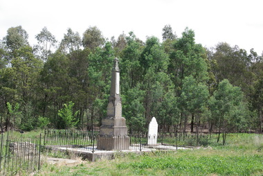 Ballarat Heritage Services
Photograph - Photograph - Colour, Clare Gervasoni, Edward Stone Parker Gravestone in the Franklinford Cemetery, 2015, 25/10/2015
... Mt Franklin Protectorate... mary parker joseph parker Mt Franklin Protectorate Loddon ...Gravestone of Edward Stone Parker and family in the Franklinford Cemetery, Victoria.Edward Stone Parker was an Assistant Protector of Aborigines on the Loddon or Mt Frankin Protectorate.The Parker cemetery plot at Franklinford Cemetery, Victoria. edward stone parker, e.s. parker, franklinford cemetery, aboriginal protector, mary parker, joseph parker, mt franklin protectorate, loddon protectorate -
Ballarat Heritage Services
Document, Castlemaine Resarch Notels for CAGHM interpretation
... Mt franklin Protectorate... Wurrung Mt franklin Protectorate Edward Stone Parker Alexander ...Word doc of resarch relating to Castlemaine, Victoriacastlemaine swimming pool, aboriginies, major mitchell, gold, commerce, religion, education, sport, music, federation, geology, dja dja wurrung, mt franklin protectorate, edward stone parker, alexander kennedy, campaspe, coliban, mount alexander, muckleford, plaistowe, joyce borthers, strathloddon, yapeem, straford lodge, james orr, chinese, campbell's creek, yapeen, fryers creek, guildford, harcourt, newstead, yappen -
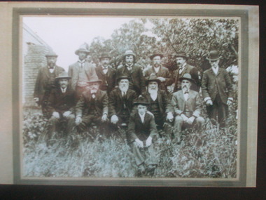 Ballarat Heritage Services
Photograph - Colour, Mount Franklin Shire Council
... . The weatherboard building to the left is possibly the Mt Franklin Shire.... The weatherboard building to the left is possibly the Mt Franklin Shire ...This photograph may have been taken beside the Mount Franklin Shire Town Hall, which was destroyed by fire in 1906.Black and white photograph of the Mount Franklin Shire Council. Seated at right is Councillor Luigi Gervasoni. The weatherboard building to the left is possibly the Mt Franklin Shire Hall which was destroyed by fire in 1906.mount franklin shire council, luigi gervasoni -
 Ballarat Heritage Services
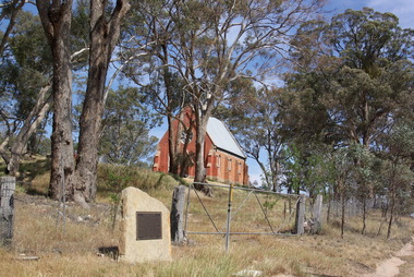
Photograph - Photograph - Colour, Clare Gervasoni, Edward Stone Parker Memorial, Franklinford, 25/10/2015
... Franklinford is in the 'shadow' of Mt Franklin, the site... and an Inspiration. April 1965." Franklinford is in the 'shadow' of Mt ...Franklinford is in the 'shadow' of Mt Franklin, the site of Edward Stone Parker's Aboriginal Protectorate.Photograph of a stone memorial cairn to Edward Stone Parker, Protector of Aborigines. "Edward Stone Parker 1802-1865 Regional Pioneer, Protector of Aborigines Established the Loddon Aboriginal Station Homestead, Church and School near this site in 1841. His devoted service remains a challenge and an Inspiration. April 1965."edward stone parker, protector of aboriginies, aboriginal protectorate, loddon aboriginal protectorate, franklinford aboriginal protectorate, franklinford -
 Ballarat Heritage Services
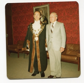
Photograph - Colour, Mayor of Kew Cr John Hogan Gervasoni, and Gus Gervasoni
... Daylesford. He served for the Mt Franklin Road Board in the early..., and settled at Yandoit Creek near Daylesford. He served for the Mt ...Cr John H. Gervasoni's great grandfather was born in Bergamo, Lombardy, Italy, and settled at Yandoit Creek near Daylesford. He served for the Mt Franklin Road Board in the early 1900s.Colour photograph of Mayor of Kew Cr John Hogan Gervasoni, and his father Gus Gervasoni. The photo is taken at the Kew Civic Centre in Charles Street, Kew. john hogan gervasoni, gus gervasoni, mayor, cit of kew, kew civic centre -
Victorian Aboriginal Corporation for Languages
Book, C C Culvenor, The boundaries of the Mount Franklin Aboriginal Reserve, 1992
... to the general reader" --Preface. Contents: The boundaries of the Mt...: The boundaries of the Mt. Franklin Aboriginal Reserve The five mile ..."This enquiry into the boundaries of the Mount Franklin Aboriginal Reserve had its origins in the preparation of a biography of geologist Thomas Smith of Sandon, which raised queries about Boundary Gully Road, Parkers Gully and the location in that vicinity of the Reserve boundary. At a subsequent meeting of the Daylesford Historical Society, commemorating the 150th anniversary of the founding of the Aboriginal Reserve at Franklinford in 1841, it became clear that the actual boundaries were only poorly known ... A search for information srouces in Melbourne and Sydney did not produce an overall Plan, but it is hoped that the material obtained will present a sufficiently accurate picture to be useful to other local historians and be of some interest also to the general reader" --Preface. Contents: The boundaries of the Mt. Franklin Aboriginal Reserve The five mile radius The Tarrengower challenge Provisional boundaries Survey of the Reserve Breakup of the Reserve References Appendices.maps, b&w illustrations, b&w photographsmount franklin -
 Victorian Aboriginal Corporation for Languages
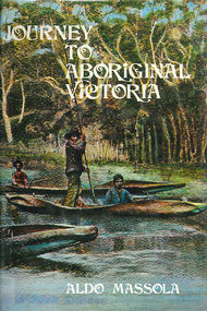
Book, Aldo Massola, Journey to Aboriginal Victoria, 1969
... ; camp sites at Mt. Franklin; Chap.11; Charlton - belief... at Mt. Franklin; Chap.11; Charlton - belief in Mindye (snake ...Looks at the Aboriginal community from the time of white contact, across many parts of Victoria. Chap.1; Melbourne - early missions, camp of Native Police, corroboree trees, canoe trees, grave &? headstone of Derrimut; quarries at Keilor, excavation sites at Green Gully &? Keilor; quarry at Mt. William, notes on inheritance of quarries Coranderrk settlement - Barraks grave, notes on his life; Chap.2; Geelong - Yawangi group of the Wothowurong tribe, camping grounds in area quarries; Notes on William Buckley, Gellibrand (a notable Aboriginal), graves in the Western Cemetery; Chap.3; Colac - war between Colac &? Geelong tribes; Mission at Birregurra, reason for failure of Buntingdale Mission; brass plate to Coc-coc-coine; reserve at Elliminyt, native ovens, camp sites, initiation site &? ritual; quarry sites, axegrinding factory, rock pecking &? engraving; dried hand &? 3 Aboriginal skulls found; Chap.4; The south-west coast - middens, camp sites notes on Framlingham Stn., fish traps at Tyrendarra; Chap.5; The far west - massacres of Aborigines near Casterton; camp sites, oven mounds; the first cricket team formed; Aboriginal cemetery; Chap.6; Hamilton - camps; Mount Rouse Station, axegrinding grooves at Nareeb Nareeb, shelters described, fish traps, massacre at Lake Condah; mission; canoes; Chap.7; Camperdown - legend about Lake Bullen Merri; obelisk erected in memory of Aborigines of district especially chief Wombeetch Puyuun; Jarcoort tribe; fish weirs, camps, intertribal fights between Booluc-burrers, Jarcoorts &? Ellengermote groups; bartering place at Mount Noorat; articles traded, legend of Flat-Top Hill; Chap.8; Ballarat - camp at Lake Wendouree; White Stone Lagoon; legends concerning Mt. Buninyong &? waterfalls at Lal-lal; camp sites; pygmy-type implements near Meredith, quarry at Glue Pot Rocks near Durdidwarrah; brass plate of King Billy; Chap.9; Ararat - Tjapwurong territory; camp sites, quarries, shield &? canoe trees; Bunyip belief at Lake Buninjon of Muk-jarawaint &? Pirtkopen-noot tribes, gives legend; stone implements; mill stones; fish weirs; stone arrangement near Lake Wongan; ground drawing of a bunyip, paintings in rock shelter near Mt. Langi Ghiran; Chap.10; Maryborough - camps, oven mounds, rock wells, stone arrangement at Carisbrook; camp sites at Mt. Franklin; Chap.11; Charlton - belief in Mindye (snake); canoe trees, ovens, camp sites, water holes, rock wells, stone implements; method of rainmaking; Chap.12; Horsham-Stawell, The Wimmera - Wotjobaluk land; camps, fish traps at Toolondo; Black Range cave paintings, Flat Rock shelters (detailed account of these paintings); Bunjils Cave; Chap.13; Horsham-Stawell, The Mallee - camp sites, implements; Ebenezer Mission, Willie Wimmera taken to England by Rev. Chase to become a missionary, died in England; Chap.14; The Murray River, Mildura Swan Hill - Battle of the Rufus; ceremonial ground, Lake Gol Gol, canoe &? shield trees; stone implements; camp sites, fire place arrangements; fish traps; oven mounds; Chap.15; The Murray River, Swan Hill-Echuca - legend about Lake Boga; camps, oven mounds, the Cohuna skull, Kow Swamp, method of burial; Chap.16; Shepparton ovens; brass plates of King Paddy of Kotupna &? King Tattambo of Mulka Stn., native well, camps; Chap.17; Wangaratta -camps, quarry, rock holes, the Faithful massacre; grinding rocks at Earlston; Chap.18; The High Plains - Ya-itma-thang; camps, Bogong moth feasts, native paths for trade &? intertribal fights, articles traded; painted shelters; Koetong Ck. Valley, near Mt. Pilot &? near Barwidgee Ck.; Chap.19; Dandenong - water holes, list of 8 holes in Beaumaris - Black Rock area; camps, middens, stone implements (microliths), legend of Angels Cave, stone axes, Native Police Force, Narre Narre Warren Station, legend about rocks on Bald Hill, kangaroo totemic site; Chap.20; Wonthaggi- Yarram - natives visit Phillip Is., murder of William Cook and Yankee by five Tasmanians (listed as Bon Small Boy, Jack Napoleon Timninaparewa, Fanny Waterpoordeyer, Matilda Nattopolenimma and Truganini) near Cape Patterson, men; camp sites, middens, legend of White Rock; Chap.21; Sale - Bairnsdale, The Lakes Country middens, camps; legend at Wulrunjeri; story of a white woman supposedly living with with the Tutangolung tribe, efforts made to prove story; canoe trees; Chap.22; Sale-Bairnsdale, The Inland Braiakolung tribe, camps, implements, canoe &? shield trees; Ramahyuck Mission, grinding rocks, fights with Omeo tribe; native tracks, death through enemy magic - procedure, belief in ghosts; Chap.23; Lakes Entrance and the Country to the east - Kroatungolung people, legend of Kalimna Valley; camps, stones of Nargun, bunyip, devils at Lake Tyers, excavation at Buchan, carbon dates; middens, ochre at Cape Conrad, stone fish-hook file at Thurra River; note on Bidwel tribe; Each chapter gives historical details, early contacts, relationships with settlers; Aboriginal place names and detailed description of sites and geographical features.b&w photographs, b&w illustrations, colour illustrationsgeelong, colac, hamilton, camperdown, ballarat, ararat, maryborough, charlton, horsham, stawell, murray river, shepparton, wangaratta, dandenong, wonthaggi, yarram, sale, bairnsdale, lakes entrance -
 Federation University Historical Collection
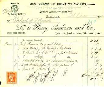
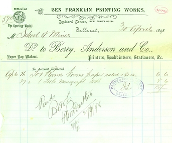
Document, Invoice from Benjamin Franklin Printing Works, 1896, 31/012/1896
Invoice to the Ballarat School of Mines from the Ben Franklin Printing Works (Berry, Anderson and Co.) . A red Victoria one penny stamp is attached to the invoice.benjamin franklin printing works, berry, anderson and co, ballarat school of mines, philately, letterhead, printer, bookbinder, stationer -
 Federation University Historical Collection
Document, Invoices to the Ballarat School of Mines, 1898
Invoices to the Ballarat School of Mines. .7) Invoice from Ben Franklin Printing Works (Berry Anderson and Co.)ballarat school of mines, letterhead, invoices, ben franklin printing works, berry, anderson and co, lydiard street, printer, bookbinder, stationer -
 Federation University Historical Collection
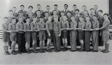
Photograph - Image, Ballarat Junior Technical School Choir, 1956
The Ballarat Junior Technical School Back Row L-R: R.J. King, J. Halliday, B. Antonio, P. Montgomery, W. Wilkins, G. Kiddie, J. Clarke, G. Nicholls, K. Burge, J. Gullock Middle Row L-R: W. Doyle, I. Treganza, M. Moore, D. McLeod, B. Gamble, M. Elsey, W. Dowler Front Row: J. Taylor, G. Caddy, B. Flood, G. Rapkins, R. Whitten, R. Priddle, R. Wilson. J. Carroll, M. Tucker, F. Trigg, I. Franklin, N. Dell, N. Yean, C. Judd.ballarat junior technical school, choir, r.j. king, j. halliday, b. antonio, p. montgomery, w. wilkins, g. kiddie, j. clarke, g. nicholls, k. burge, j. gullock, w. doyle, i. treganza, m. moore, d. mcleod, b. gamble, m. elsey, w. dowler, j. taylor, g. caddy, b. flood, g. rapkins, r. whitten, r. priddle, r. wilson, j. carroll, m. tucker, f. trigg, i. franklin, n. dell, n. yean, c. judd -
Federation University Historical Collection
Book, South West Gippsland Tourism Development Strategy, 1989, c1999
Black plastic binding on a report tourism and development strategy report.tourism, tourism strategy, south west gippsland, gippsland, coal creek historical town, wilsons promontory, penguin parade, grand prix, grand ridge road, wonthaggi, phillip island, foster korumburra, inverloch, kilcunda, san remo, bass, bunurong marin park, port franklin, tarwin lower -
Federation University Historical Collection
Book, From Timber to Tourism: Exploring Place Attachment and Natural Area Values in the Otway Ranges, 1997
Spiral bound reportuniversity of ballarat, school of business, tourism, apollo bay, otway national park, michelle brown, melinda gill, clare kearns, sarah mcewing, renee walder, cape otway lighthouse, point franklin residential estate, harbour, sand dune erosion, great ocean road, blanket bay, maits rest walking track -
Federation University Historical Collection
Book, Amanda Lockey, Analysis of Visitors to Hepburn Regional Park, 1996
Black plastic piral bound reportuniversity of ballarat, school of business, tourism, hepburn regional park, hepburn springs, daylesford, mount franklin, blowhole, wombat state forest, three lost children -
 Federation University Historical Collection
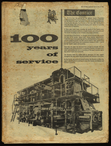
Newspaper, The Courier, 100 years of service, 1967, 10/06/1967
The newspaper was produced to celebrate the 100th year of the Ballarat Courier.96 page newspaper celebrating 100 years of publishing the Ballarat Courier Newspaper. Stories and images include: Robert Clark, Ballarat history, Sturt Street, Selkirk Bricks, Ballarat Industry, Thomas Bath, Royal Hotel, hotels, Begonia Festival, James Smith, Hollways, Myers, Ballarat Orphanage, Nazareth House, Lake Elsworth, Batches, libraries, Timken, Sunshine Biscuits, M.B. John, AMCAST, reservoirs, Ballarat Council,, Morsheads, Civic Hall, Alfred Hall, Art Gallery, Christies, 3BA, Paddle Bros, South Street, BTV 6, Memorial Theatre, Her Majesty's, Whitelaw-Monier, Coltman, costume, Messer and opie, politics, Dudley Erwin, Bill Stephen, Vance Dickie, Tom Evans, Murray Byrne, McKay - Macleod, Crockers, Ballarat Shire, Sovereign Hill. St Patrick's Cathedral, Christ Church Cathedral, Ballarat School of Mines, Mt Helen Campus, Ballarat Girls School. Ballarat North Technical School , Burke and Wills Memorial, Joe White Maltings, Ballarat Airport, Sunicrust, architecture, women, trams, transport, Faulls, Franklin Caravans, Olympics, football, history of Sunshine Biscuits robert clark, clark, ballarat, sturt street, selkirk bricks, industry, thomas bath, royal hotel, hotels, begonia festival, james smith, hollways, myers, ballarat orphanage, nazareth house, lake elsworth, batches, libraries, timken, sunshine biscuits, m.b. john, amcast, reservoirs, ballarat council, morsheads, civic hall, alfred hall, art gallery, christies, 3ba, paddle bros, south street, btv 6, memorial theatre, her majesty's, whitelaw-monier, coltman, costume, messer and opie, politics, dudley erwin, bill stephen, vance dickie, tom evans, murray byrne, mckay - macleod, crockers, ballarat shire, sovereign hill. st patrick's cathedral, christ church cathedral, ballarat school of mines, churches, mt helen campus, ballarat girls school. ballarat north technical school, burke and wills memorial, joe white maltings, ballarat airport, sunicrust, architecture, women, trams, transport, faulls, franklin caravans, olympics, football, bray raceway, coliseum motors, schoools, education, craig bros, dayelsford, clunes, beaufort, linton, skipton, heinz bors, villiers, flecnoe, jones, robertson, cowles, bulless, cronn, matthews, ballarat library, cowley's eureka iron works, john hollway and sons, ken webb, mayoral chain, ken flecknoe, a.e. flecknoe, bath's hotel, eureka stockade memorial park -
 Federation University Historical Collection
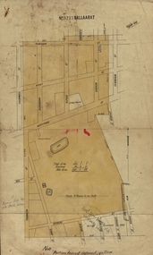
Plan, Ballaarat No 5722, 28/11/1903
Part of the block shaded yellow on the plan contains Phoenix P-12 School Senior CampusPlan of Ballarat with leae area No 5722 coloured yellow. Plan of the streets around Hertford Street, ballarat. The yellow depicts the area leased (No 5722 Ballarat)mining lease 5722 ballarat, ballarat, hertford street, cromwell street, alexandra street, alfred street, verdon street, clarkson street, spencer street, franklin street, hill street, grant street, albion street, rowlands street, edwards street north, mining, cgt, plans, phoenix p-12 school senior campus -
 Federation University Historical Collection
Book, Franklin B. Carroll, Understanding Our World, 1939
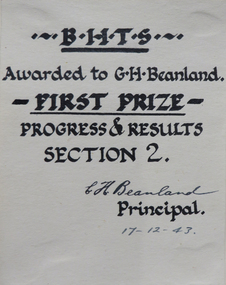
Graham Beanland became a Principal at the Ballarat School of Mines. Green hardcovered book awarded to Graham. Beanland for first prize (Progress and Results) at B.H.T.S. The book has many illistrations. B.H.T.S. Awarded to G.H. Beanland. First Prize Progress and Results Section 2 E.H. Beanland Principal 17-12-43graham beanland, g.h. beanland, c.h. beanland, stars, planeta, seasons, weather, climate, water, plants, energy, heat, magnetism, electricity -
Federation University Historical Collection
Magazine, Quadrangle: The Magazine of the Ballarat Junior Technical School, 1962
The Ballarat Junior Technical School was a division of the Ballarat Schoo of Mines.Blue soft covered book of 32 pages.ballarat junior technical school, r.r. watson, k.g. hamilton, r. franklin, r. karvinen, michael chung, keith e. rash, old boys association, robert titheridge, bruce mckinnon, robert baldock, max berriman, john bettles, colin hughes, reijo karvinen, william lowe, bill lowe, ian pym, robert withers, lindsay hocking, paul clifton, z. albert, p. seddon, aistralian air training school -
 Kiewa Valley Historical Society
Photograph of Kiewa Valley Pioneer Family, Three Generations of Kiewa Valley Pioneer Family (Coopers), late 1900s'
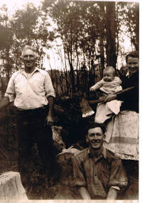
This historical family photograph spans three generations of the Cooper Family, a pioneer family, still residing in the Kiewa Valley. The large axe held by Pat was a handy tool for pioneer families to chop down trees for land clearing, building sheds and fences, outhouses and fire wood. This photograph was taken during a time where both male and females did some heavy lifting and processing. The rural sector at this point in time was physically a hard location for both sexes. The segregation of the sexes into specific job categories was some times non existent although household "chores" was in the main a woman's domain. The rural sector was in this point of time one which women were highly respected and the unwritten law of providing "assistance" and "reverence" by men in such actions as, socially opening doors, tipping the cap, offering a sturdy arm for support and refraining from doing or saying anything "uncouth" in a woman's presence. It was in a time when women's liberation was just starting to grow strength. Rural areas, on the hole, took longer to interfuse "city" hatched norms of behaviour. This photograph of a pioneer family still residing in the Kiewa Valley demonstrates not only the close protective environment that the valley has on all its inhabitants but also the close bonding that neighbors have towards each other. The term "God's gifted country" fits warmly with all the settlements in the valley. The relatively isolated (physically, visually and communications wise) has since post World War II been whittled away by faster and vastly improved communications with "the outside" world. The strength of commitment to the rural life can be seen in the faces of the family members in this photograph. The proud heritage is displayed without any external pressure. This large black and white family photograph is a reproduction on Fujicolor Crystal Archive Paper manufactured by Fujifilm. It is 200gsm matt finished paper with no borders. On the reverse side, written in pencil "Ted Cooper sitting aged 24-25, Pat Amery (Ted's youngest sister) holding Ted's eldest son Doug and Ted's father John Franklin Cooper(22-8-1892)"john cooper, ted cooper, pat amery, doug cooper, pioneer family kiewa valley -
 Kiewa Valley Historical Society
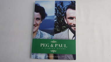
Book - Peg and Paul - A Family Story, Peg and Paul - A Family Story by Wendy Boehringer
Family History of the Cooper and Boehringer families commencing with John Franklin Cooper 1892-1982 and Gertrude Beatrice Wallace Robinson 1901 - 1991Social history of life in the Kiewa Valley during the 20th Century.Coloured cardboard cover with a photo of the halves of two people. The title is white on green across the bottom third.192 pages cooper family, boehringer family, farming in the kiewa valley -
Federation University Historical Collection
Document, Heather Holst, 'Save the people': E.S. Parker at the Loddon Aboriginal Station, 2008
A chapter from Aboriginal History 2008, Volume 32edward stone parker, e.s. parker, loddon aboriginal station, mount franklin aboriginal station, aboriginal protectorate, port phillip protectorate, loddon station, mary cooke woolmer, joseph parker, mary parker, franklinford, dja dja wurrung, hannah edwards, james bodkin, hannah parker, mount franklin house, edward parker, john knox, tommy farmer, beembarmin, yerrebulluk, norah farmer, aboriginal farmers, coranderrk, willie parker, kolain, george robinson, -
 Ballarat Heritage Services
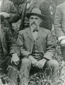
Photograph - Photograph - Black and White, Luigi Gervasoni of Yandoit Creek, Victoria, Pre 1895
George Gervasoni was the son on Luigi and Eliza Gervasoni. He was born at Yandoit Creek, Victoria. George Gervasoni married Anne Pedretti and they lived in Daylesford, where they both died. They are buried in Eganstown Catholic Cemetery. Black and white photograph of Luigi Paolo Gervasoni, of San Gallo, Bergamo, Italy. Luigi was the Son of Nicola Gervasoni and Giovanina Gervasoni of San Gallo. This photo is a detail from the Mt Frankklin Shire Council. yandoit creek, luigi gervasoni, mount franklin shire council